

| Standard Report | Premium Report | |
|---|---|---|
| Current State of the Industry |  |
|
| Market Size (industry trends) | |
|
| Market Forecast (5-year projection) | |
|
| Products/Services Breakdown | |
|
| Revenue per State | |
|
| Financial Metrics | |
|
| Salary & Compensation Statistics | |
|
| Public Company Information | |
|
| Key Private Companies | |
|
| Government Vendors | |
|
| Instant Download - Available immediately upon purchase | |
|
| Download both PDF and Excel
|
|
|
| Download now: |


2026 U.S. Industry Statistics & Market Forecast - Geophysical Surveying and Mapping Services
Market Size & Industry Statistics
The total U.S. industry market size for Geophysical Surveying and Mapping Services:
Industry statistics cover all companies in the United States, both public and private, ranging in size from small businesses to market leaders.
In addition to revenue, the industry market analysis shows information on employees, companies, and average firm size.
Investors, banks, and business executives use growth rates and industry trends to understand the market outlook and opportunity.
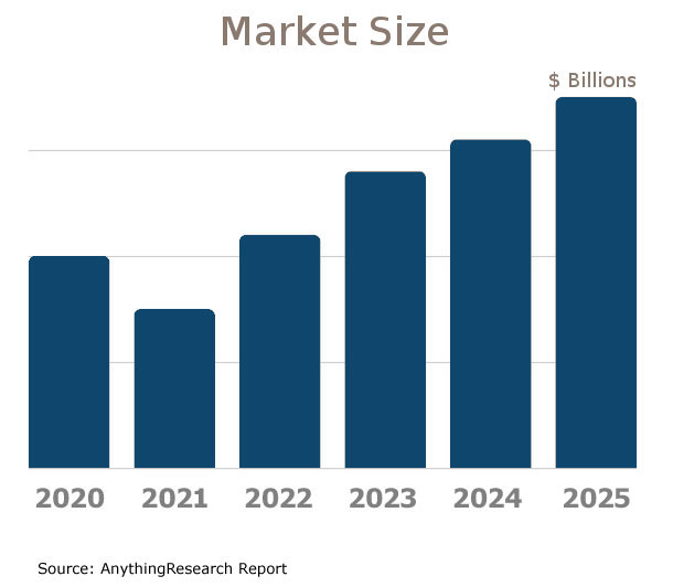
| Statistics | 2020 2021 2022 2023 2024 2025 | |
|---|---|---|
| Market Size (Total Sales/Revenue) |
Order at top of page | |
| Total Firms | ||
| Total Employees | ||
| Average Revenue Per Firm | ||
| Average Employees Per Firm | ||
| Average Revenue Per Employee | ||
Market Forecast
Market forecasts show the long term industry outlook and future growth trends. The following extended five-year forecast projects both short-term and long-term trends.
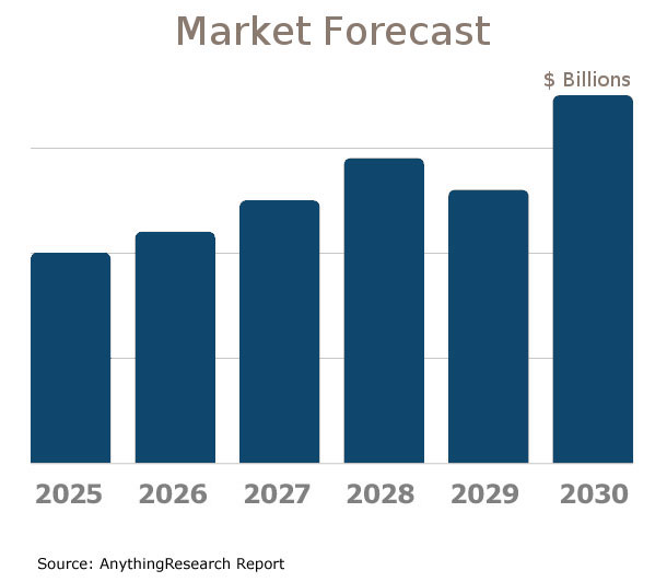
| Forecast / Industry Outlook | 2025 | 2026 | 2027 | 2028 | 2029 | 2030 |
|---|---|---|---|---|---|---|
| Market Forecast ($ millions) | ||||||
| Projected Industry Growth Rate (%) | ||||||
Industry Insights
Major trends affect the Geophysical Surveying and Mapping Services industry include:- Increased demand for renewable energy projects
- Advancements in remote sensing technology
- Integration of AI and machine learning
- Growing environmental concerns and regulations
- Expansion of offshore oil and gas exploration activities
- Enhanced data analytics capabilities
- Global economic and political fluctuations
- Rising competition from in-house geological survey teams
- Technological innovations in drones and unmanned vehicles
- Shift towards sustainable practices and green technology
- Increased use of geospatial data in urban planning and development
- Demand for high-resolution 3D and 4D seismic imaging techniques
- Growth in infrastructure projects in developing nations
- Higher scrutiny around data privacy and cybersecurity
- Increased outsourcing of surveying services to cost-effective regions
Product & Services Breakdown
Research products and services in the Geophysical Surveying and Mapping Services industry generating sales. Note that products are broken into categories with different levels of classification.| Product Description | Number of Companies | Sales ($ millions) | Percent of Total Sales |
|---|---|---|---|
Industry Total |
|||
Geophysical Data Collection |
|||
Geophysical Data Acquired By Seismic Methods |
|||
Geophysical Data Processing |
|||
Integrated Geophysical Services |
|||
Processing And Interpreting Geophysical Data |
|||
Geophysical Borehole Logging Surveys |
|||
Acquiring And Processing Geophysical Data Collected By Seismic Methods |
|||
Geophysical Data Sales |
|||
Geophysical Data Management Services |
|||
Geophysical Consulting Services (Include Expert Witness Services.) |
|||
All Other Receipts |
|||
All Other Operating Receipts |
|||
U.S. Geographic Distribution: Revenue Statistics by State
Market Size by State ($ millions) indicates how the industry's competition is distributed throughout the country. State-level information can identify areas with higher and lower industry market share than average.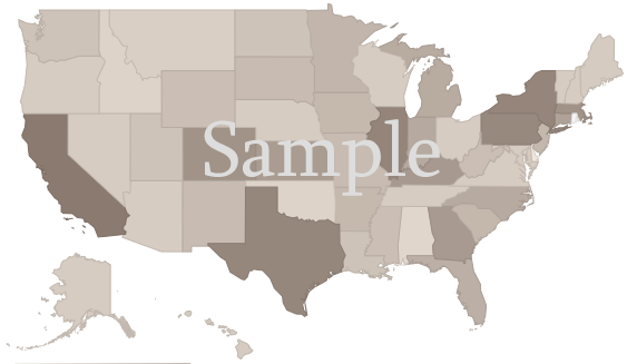
Income Statement (Average Financial Metrics)
Financial metrics provide a snapshot view of a benchmark "average" company. Key business metrics show revenue and operating costs. The data collected covers both public and private companies.| Industry Average | Percent of Sales (Industry Benchmark) |
|
|---|---|---|
| Total Revenue | Order at top of page |
|
| Operating Revenue | ||
| Cost of Goods Sold | ||
| Gross Profit | ||
Operating Expenses | ||
| Pension, profit sharing plans, stock, annuity | ||
| Repairs | ||
| Rent paid on business property | ||
| Charitable Contributions | ||
| Depletion | ||
| Domestic production activities deduction | ||
| Advertising | ||
| Compensation of officers | ||
| Salaries and wages | ||
| Employee benefit programs | ||
| Taxes and Licenses | ||
| Bad Debts | ||
| Depreciation | ||
| Amortization | ||
| Other Operating Expenses | ||
| Total Operating Expenses | ||
| Operating Income | ||
| Non-Operating Income | ||
| EBIT (Earnings Before Interest and Taxes) | ||
| Interest Expense | ||
| Earnings Before Taxes | ||
| Income Tax | ||
| Net Profit Net Income | ||
Financial Ratio Analysis
Financial ratio information can be used to benchmark how a Geophysical Surveying and Mapping Services company compares to its peers. Accounting statistics are calculated from the industry-average for income statements and balance sheets.| Profitability & Valuation Ratios | Industry Average |
|---|---|
| Company valuation can be measured based on the firm's own performance, as well as in comparison against its industry competitors. These metrics show how the average company in the Geophysical Surveying and Mapping Services industry is performing. | |
| Profit Margin Gross Profit Margin, Operating Profit Margin, and Net Profit Margin. Show company earnings relative to revenues. |
|
| Return on Equity (ROE) Return on Equity (ROE) is net income as a percentage of shareholders' equity. Shareholders' Equity is defined as the company's total assets minus total liabilities. ROE shows how much profits a company generates with the money shareholders invested (or with retained earnings). |
|
| Return on Assets (ROA) Return on Assets (ROA) is net income relative to total assets. The market research on Geophysical Surveying and Mapping Services measures how efficiently the company leverages its assets to generate profit. ROA is calculated as Net Income divided by Total Assets. |
|
| Liquidity Ratios | Industry Average |
|---|---|
| Bankers and suppliers use liquidity to determine creditworthiness and identify potential threats to a company's financial viability. | |
| Current Ratio Measures a firm's ability to pay its debts over the next 12 months. |
|
| Quick Ratio (Acid Test) Calculates liquid assets relative to liabilities, excluding inventories. |
|
| Efficiency Ratios - Key Performance Indicators | Industry Average |
|---|---|
| Measure how quickly products and services sell, and effectively collections policies are implemented. | |
| Receivables Turnover Ratio If this number is low in your business when compared to the industry average in the research report, it may mean your payment terms are too lenient or that you are not doing a good enough job on collections. |
|
| Average Collection Period Based on the Receivables Turnover, this estimates the collection period in days. Calculated as 365 divided by the Receivables Turnover |
|
| Inventory Turnover A low turnover rate may point to overstocking, obsolescence, or deficiencies in the product line or marketing effort. |
|
| Fixed-Asset Turnover Generally, higher is better, since it indicates the business has less money tied up in fixed assets for each dollar of sales revenue. |
|
Compensation & Salary Surveys for Employees
Compensation statistics provides an accurate assessment of industry-specific jobs and national salary averages. This information can be used to identify which positions are most common, and high, low, and average annual wages.| Title | Percent of Workforce | Bottom Quartile | Average (Median) Salary | Upper Quartile |
|---|---|---|---|---|
| Management Occupations | 10% | Order at top of page |
||
| Chief Executives | 0% | |||
| General and Operations Managers | 3% | |||
| Business and Financial Operations Occupations | 11% | |||
| Business Operations Specialists | 9% | |||
| Computer and Mathematical Occupations | 6% | |||
| Computer Occupations | 6% | |||
| Architecture and Engineering Occupations | 45% | |||
| Architects, Surveyors, and Cartographers | 9% | |||
| Architects, Except Naval | 7% | |||
| Architects, Except Landscape and Naval | 6% | |||
| Engineers | 23% | |||
| Civil Engineers | 10% | |||
| Civil Engineers | 10% | |||
| Drafters, Engineering Technicians, and Mapping Technicians | 13% | |||
| Drafters | 6% | |||
| Engineering Technologists and Technicians, Except Drafters | 5% | |||
| Office and Administrative Support Occupations | 8% | |||
Geophysical Surveying and Mapping Services Competitor Landscape & Key Companies [PREMIUM]
The most influential companies in the Geophysical Surveying and Mapping Services industry and adjacent industries either have large market share or are developing new business models and methods that could disrupt the status quo. We look at leading and emerging companies in the Geophysical Surveying and Mapping Services industry and adjacent sectors:| Market Leaders: Direct Competitors Companies with the largest market share, focused in this industry |
Market leaders: Diversified Competitors Largest companies that have diversified operations in this and other industries |
| Innovators: Direct Competitors Innovative, Emerging, and Disruptive Companies that may influence the future direction of the industry. |
Innovators: Diversified Competitors Innovators and Disruptors in adjacent industries that may also affect the Geophysical Surveying and Mapping Services industry. |

Latest Industry News
- Hercules Metals Completes District-Scale MT-NSIP Survey on Hercules Property, Idaho - Detailed price information for Hercules Metals Corp (BIG-X) from The Globe and Mail including charting and trades. (07/09/2025)
- Class 1 Nickel Commences 2025 Exploration Program at the River Valley PGE-Cu-Ni Project, Ontario, Canada - Class 1 Nickel and Technologies Limited (CSE: NICO | OTCQB: NICLF) ('Class 1” or the 'Company') is pleased to announce the launch of its 2025 summer exploration program on its 100%-owned River Valley PGE-Cu-Ni Project (the 'RV Project” or the 'Property”), (07/09/2025)
- Standard Uranium Announces Mobilization of Exploration Crews to the Corvo Uranium Project, Northern Saskatchewan - Detailed price information for Standard Uranium Ltd (STND-X) from The Globe and Mail including charting and trades. (07/08/2025)
- Foremost Clean Energy Ltd. to Launch 5,000 Line-Kilometer Airborne Geophysical Survey on Athabasca Basin Uranium Properties - Nasdaq - Foremost Clean Energy Ltd. announced plans to conduct a 5,000 line-kilometer MobileMT™ airborne geophysical survey over its GR and Blackwing Uranium Properties in Saskatchewan's Athabasca Basin. (07/07/2025)
- Ongold Announces Initiation Of Comprehensive Exploration Program At The Monument Bay Gold And Tungsten Project - July 7, 2025) - ONGold Resources Ltd. (TSXV: ONAU) (OTCQB: ONGRF) (the " Company " or " ONGold ") is extremely pleased to announce that the Company has initiated summer exploration activities at its Monument Bay Gold and Tungsten Project (" Monument Bay "). (07/07/2025)
- Bonterra Resources Provides Exploration Updates at Phoenix JV with Gold Fields - To date, over 65,000 meters (" m ") have been drilled, with approximately C$20 million invested in the Project under the JV Agreement. The current work includes two gravity surveys, one airborne and one ground base, as well as field activities such as soil sampling, prospecting and mapping of outcrops and review of historical trenches. (07/02/2025)
- Fugro wins contract for Eastern Mediterranean gas project - Fugro, a Netherlands-based company specialising in geological data, has secured a contract to conduct a comprehensive site characterisation programme for Italian energy company Eni's deep-water gas project in the Eastern Mediterranean. (06/27/2025)
- Apex Reports Geophysical Results at Its Lithium Creek Project in Churchill County, Nevada - Nasdaq - Apex Resources Inc. is pleased to announce the results of its inaugural geophysical survey recently completed over a portion of its Lithium Creek Project in Churchill County, Nevada. Gravity and ... (06/24/2025)
- Mapping Ireland's peatlands to help cut carbon emissions - RTÉ - Mapping more accurately than ever Ireland's peatlands, which are vital as carbon sinks but whose boundaries can be hard to determine, could help fight global warming, researchers say. (06/11/2025)
- Class 1 Nickel Airborne Geophysical Survey Identifies Multiple New Targets at River Valley PGE-Cu-Ni Project, Ontario, Canada - Technical information and data in this news release has been reviewed and approved by Dr. Scott Jobin-Bevans (P.Geo., PGO #0183), a geological consultant to the Company, and a Qualified Person under the definitions established by National Instrument 43?101. (05/27/2025)

